The bigger the hailstone, the more damage it can cause. But scientists find that predicting hailstone size can be challenging. How quickly does hail melt as it falls?
Now, you can help tackle this question by joining the SouthEAst REgion CoCoRaHS Hail (SEaRCH) project. This network of backyard weather observers includes volunteers of all ages and backgrounds who work together to measure and report hail in their local communities. SEaRCH is also part of the NASA, National Oceanic and Atmospheric Association (NOAA), and National Science Foundation supported Community Collaborative Rain, Hail, and Snow (CoCoRaHS) network, whose amateur weather sleuths report rain and snow.. These rain and snow observations are helping scientists better understand local variation in precipitation. CoCoRaHS data is regularly used by the National Weather Service, the Hydrologic Prediction Center, the U.S. Department of Agriculture, the National Drought Mitigation Center, broadcast meteorologists, research scientists, and more.
“I love the project, and I love being able to contribute meaningful data,” says Jeremy Kichler, a CoCoRaHS volunteer.
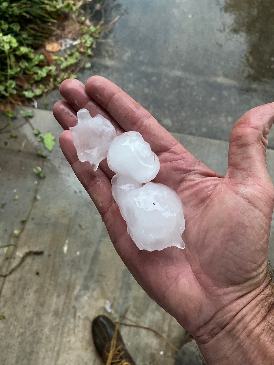
On June 14, 2023, Kichler witnessed a storm with hailstones ranging from 0.5 inches (12 mm) to two inches (51 mm) in diameter. The hailstones dented cars, damaged roof shingles, and shredded leaves across his neighborhood. After the storm, he submitted a CoCoRaHS hail report to notify the National Weather Service with photos and additional details about the hail.
NASA scientists are now using hail reports from volunteers like Kichler alongside archived satellite overpass data and newly developed hail melt profiles to model how hailstones of different sizes melt, once they fall below the freezing level.
To join volunteers like Jeremy Kichler and make hail reports of your own, all you need is your smartphone and the free CoCoRaHS mobile app. To make rain and snow reports, you’ll need a specific manual gauge approved by the National Weather Service.
Find everything you need to get started in the CoCoRaHS and SEaRCH summary on the NASA Citizen Science website.) and the National Science Foundation.
 CoCoRaHS hail photo submitted by volunteer Jeremy Kichler displaying a hand holding three large and uniquely shaped hailstones. Credit Jeremy Kichler and CoCoRaHS
 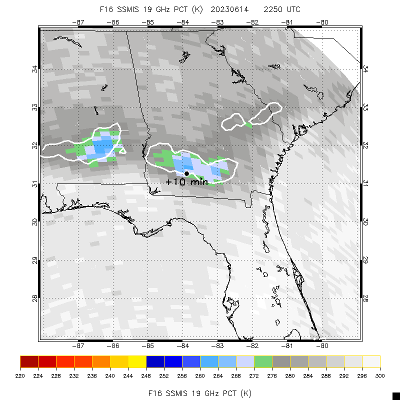 Map displaying data from the Special Sensor Microwave Imager/Sounder (SSMIS) satellite. Colors represent the probability of hail being detected (highest probability is dark red, least probability is light grey). Light blue, gray and light green pixels in the image indicate a storm over southern Georgia likely to contain hail. The black dot indicates the location of the hail reported to CoCoRaHS by Jeremy Kichler. The label “plus 10 min” indicates the satellite overpass occurred ten minutes before Jeremy’s observation of hail. Data from the Special Sensor Microwave Imager/Sounder (SSMIS). Image processing by Sarah Bang. View public map: https://maps.cocorahs.org/
View the hail report for this highlight: https://www.cocorahs.org/ViewData/ViewHailReport.aspx?HailReportID=55b8d0d2-bd76-4164-801e-d9885d214a7e
Learn More and Get Involved ![]() Community Collaborative Rain, Hail, and Snow Network (CoCoRaHS) Join a national community of precipitation reporters providing critical data to improve scientific understanding and forecasts.
Community Collaborative Rain, Hail, and Snow Network (CoCoRaHS) Join a national community of precipitation reporters providing critical data to improve scientific understanding and forecasts.
Facebook logo @nasascience_ @nasascience_ Instagram logo @nasascience_ Linkedin logo @nasascience_
Details Last Updated Mar 17, 2026 Related Terms Citizen Science Earth Science Earth Science Division
 3 min read A Bit of Gray on an Emerald Isle Ireland is best known for its many greens, but the striking grays of the island’s…
Article
9 hours ago
 3 min read Cañon Fiord’s Whirling Waters During the 2022 summer melt season, sediment plumes and fractured sea ice traced swirling eddies…
Article
1 day ago
 2 min read Volunteers Find Oddly High Solar Flare Rates
Article
4 days ago