Curiosity Navigation Curiosity Home Mission Overview Where is Curiosity? Mission Updates Science Overview Instruments Highlights Exploration Goals News and Features Multimedia Curiosity Raw Images Images Videos Audio Mosaics More Resources Mars Missions Mars Sample Return Mars Perseverance Rover Mars Curiosity Rover MAVEN Mars Reconnaissance Orbiter Mars Odyssey More Mars Missions Mars Home 2 min read
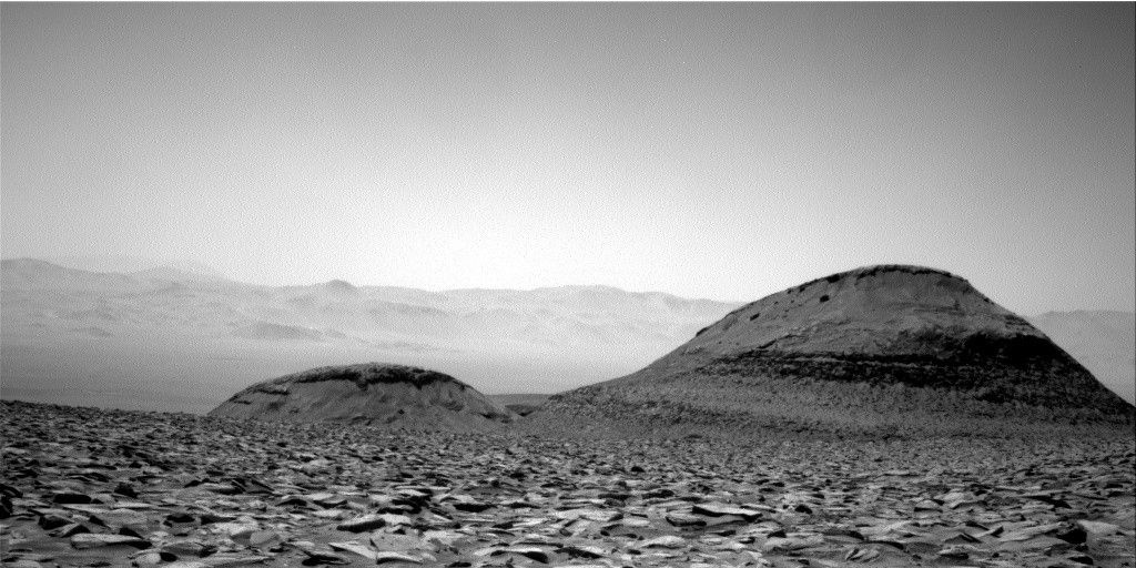
Sols 4477-4478: Bumping Back to Business  NASA’s Mars rover Curiosity acquired this image using its Right Navigation Camera on March 10, 2025 — sol 4476, or Martian day 4,476 of the Mars Science Laboratory mission — at 04:15:44 UTC. NASA/JPL-Caltech Written by Sharon Wilson Purdy, Planetary Geologist at the Smithsonian National Air and Space Museum
Earth planning date: Monday, March 10, 2025
The Curiosity rover is winding between the spectacular Gould mesa and Texoli butte through beautifully layered terrain. The end-of-drive target from last week’s plan was a rock with a knobby/bumpy texture that appears quite different from the typical surrounding bedrock. While this interesting rock was in our workspace today, we ended up being just a touch too close to do contact science. As a result, the science team decided to “bump back” (e.g., drive backwards) to get the rover in an ideal position to analyze and characterize this rock on Wednesday.
In the middle of the rover’s workspace today there was a large patch of soil and sand that MAHLI and APXS teamed up to analyze at a target named “Angeles Crest.” Nearby, Mastcam imaged troughs (depressions) along the axis of the sand ridge to understand how they formed. Mastcam had several other targets in the plan that imaged the workspace and surroundings including “Potrero John,” the knobby rock in the workspace, a rock with similar nodular textures in the distance named “Modjeska Peak,” and a light tan rock with a dome-like structure in the vicinity of “Humber Park.”
ChemCam selected a slab of bedrock and loose (“float”) rock in the workspace to characterize their geochemistry with the LIBS instrument at “Millard Canyon” and “Cajon Pass,” respectively. Off in the distance, the science team selected the face of Gould mesa and upper Texoli butte for ChemCam long distance RMI imaging to get a closer look at the rocks, fractures, and layering.
The environmental theme group scheduled several activities to look at clouds, document the atmospheric opacity, and measure the optical depth of the atmosphere and constrain aerosol scattering properties. We have lots of exciting data in hand and more on the road ahead!
Details Last Updated Mar 12, 2025 Related Terms Blogs
 3 min read Sols 4475-4476: Even the Best-Laid Plans
Article
17 hours ago
 2 min read Sealing the Deal
Article
6 days ago
 5 min read Sols 4473-4474: So Many Rocks, So Many Textures!
Article
6 days ago
Keep Exploring Discover More Topics From NASA Mars
Mars is the fourth planet from the Sun, and the seventh largest. It’s the only planet we know of inhabited…

Explore this collection of Mars images, videos, resources, PDFs, and toolkits. Discover valuable content designed to inform, educate, and inspire,…

Each robotic explorer sent to the Red Planet has its own unique capabilities driven by science. Many attributes of a…

Mars Exploration: Science Goals
The key to understanding the past, present or future potential for life on Mars can be found in NASA’s four…

